ACTIVmap
Version française disponible ici.
Computer Assisted Map Design for Visually Impaired People
ACTIVmap is a Collaborative Research Project - Enterprise (PRCE) led by the Laboratoire d'Informatique, de Modélisation et d'Optimisation des Systèmes (LIMOS, Clermont-Ferrand), jointly with the GeoVIS team from LASTIG (IGN), the ELIPSE team from Institut de Recherche en Informatique de Toulouse, and the company FeelObject.
The project is financed by the ANR (ANR-19-CE19-0005) for a period of 48 months (March 2020 - August 2024), and has received support from Aerospace Valley.


Resume
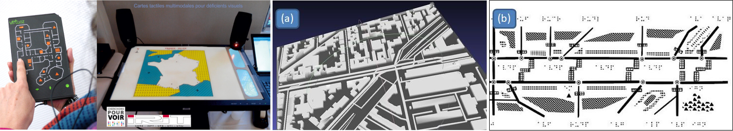
The production of maps accessible to the visually impaired people (VIPs) is nowadays a mainly artisanal practice. Scientific advances in geomatics, combined with the availability of collaborative geographic data (such as OpenStreetMap) and interactive approaches, offer original possibilities for designing such maps.
In this project, we will develop a set of interconnected tools, offering assistance in the design of maps, and allowing access modalities adapted to the diversity of disabilities and uses of these geographical representations.
The design and validation of the proposed solutions will be developed in collaboration d with representatives of the VIP community, and the results will be integrated into the products developed by the project's industrial partner.
Contact us
You can contact the members of the ACTIVmap project by writing to contact.activmap@isima.fr, and follow us on Mastodon.
Associated projects
ACTIVmap is a continuation of the ANR Accessimap and MapMuxing projects, led respectively by the GeoVIS team of the IGN, and by the IRIT laboratory of the Université Toulouse III.
ACTIVmap is also part of the LIMOS Compas project, which is generally interested in Cartography and Multisensorial Tools for Spatial Accessibility.